Boundary Waters, Routes, Forum, BWCA, BWCAW, Quetico Parkwww.BWCA.com Trip Reports - Messageboard, Forum, BWCA, BWCAW, Quetico Park
Boundary Waters Route Blog
    Trip Reports
      Trip Report - Seagull to Ogishkemuncie and back
 
  Last Visit: 04/25/2024 05:20PM

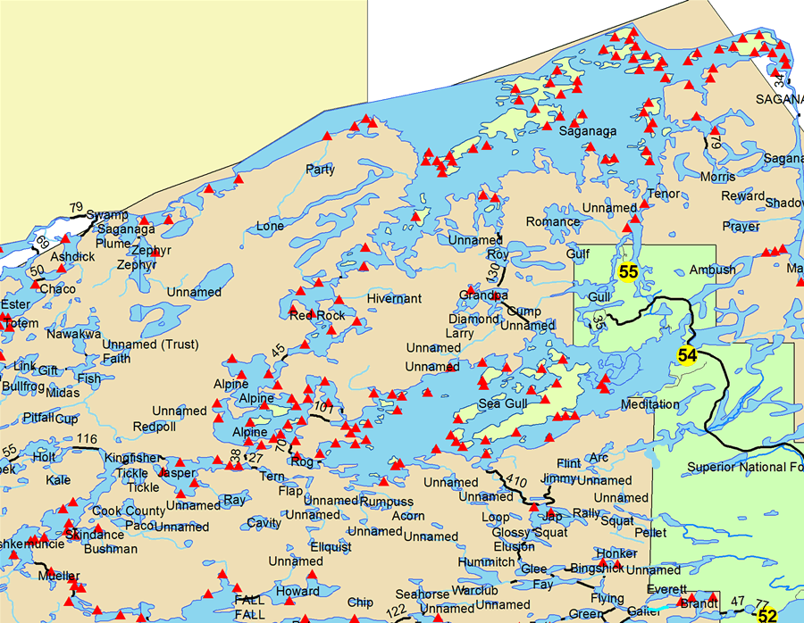
Entry Point 54 - Seagull Lake

Seagull Lake entry point allows overnight paddle or motor (10 HP (except where paddle only) max). This entry point is supported by Gunflint Ranger Station near the city of Grand Marais, MN. The distance from ranger station to entry point is 50 miles. No motors (use or possession) west of Three Mile Island. Large lake with several campsites. landing at Seagull Lake. This area was affected by blowdown in 1999.

Number of Permits per Day: 8
Elevation: 1205 feet
Latitude: 48.1469
Longitude: -90.8693
Author Message Text
rmpeterson2
membermember
 
07/13/2009 09:42PM
 
New Trip Report posted by rmpeterson2

Trip Name: Seagull to Ogishkemuncie and back.

Entry Point: 54

Click Here to View Trip Report
Reply Top Bottom Previous Next
ILikePike
distinguished memberdistinguished memberdistinguished memberdistinguished member
 
07/14/2009 11:30AM
 
Its great that you had a great tripp with your kids. I love it when i go up there with my dad.

“Wilderness is not a luxury but a necessity of the human spirit” -Edward Abbey
alpine525
distinguished memberdistinguished memberdistinguished memberdistinguished member
 
07/14/2009 12:47PM
 
You visited one of my favorite areas in the BW. Thanks for putting together a great trip report - really enjoyed the pictures.

Do not let the behavior of others destroy your inner peace. Dalai Lama
Malamom
distinguished memberdistinguished memberdistinguished memberdistinguished member
 
07/14/2009 12:49PM
 
Thanks for the report! I love that area and have great memories of a couple of trips there. I had to laugh, because the first time I/we paddled across Seagull, we got turned around at Fishhook Island, and did the same thing you did before we got to the Alpine portage.
rmpeterson2
membermember
 
07/14/2009 10:23PM
 
I thought that the exposed rocks (after the burn) would make it easier to tell what was an island and what was the opposite shore, but it seemed to be more troublesome in navigating at times than having trees on the island.
rlhedlund
distinguished memberdistinguished memberdistinguished memberdistinguished member
 
07/15/2009 06:51PM
 
Thanks for the report. Was up there in May and shared your experience with the wind, wind, wind.

Life is Good, Living is Better. Everlasting Life is Best! Pray for Us Amok.
520eek
distinguished memberdistinguished memberdistinguished memberdistinguished member
 
07/23/2009 02:30PM
 
Thanks for posting, I enjoyed the read.

I couldn't wait for success, so I went ahead without it!
Mad_Angler
distinguished memberdistinguished memberdistinguished memberdistinguished member
 
07/29/2009 02:43PM
 
Thanks for the report. It was nice read and gave a good picture of the area.


Fish where the fish are...
Reply Top Bottom Previous Next
Routes
Trip Reports
a
.
Routes
Trip Reports
Routes
Trip Reports
Routes
Trip Reports
Routes
Trip Reports
Routes
Trip Reports
.
Routes
Trip Reports
.
Routes
Trip Reports
Routes
Trip Reports
Routes
Trip Reports
x