BWCA Entry Point, Route, and Trip Report Blog
July 14 2025
Entry Point 23 - Mudro Lake

Mudro Lake entry point allows overnight paddle only. This entry point is supported by Kawishiwi Ranger Station near the city of Ely, MN. The distance from ranger station to entry point is 19 miles. Three accesses into Mudro Lake involve portages ranging from 20–185 rods.Easiest access is from private la nd with parking fee.
Number of Permits per Day: 5
Elevation: 1166 feet
Latitude: 48.0356
Longitude: -91.8301
On the Water- Monday July 20th-
On the water late considering how far we need to go today. Up the Horse river to the falls by 6pm. Started raining and NO campsites available. Mudrow-Alruss-Tin can Mike-Horse Lake-Horse River-Basswood. 13 miles by water. (not counting portages)
Tuesday July 21st-
Rain all night, all morning and all day. Went north by petroglyphs, table rock and the the Crocked Lake Narrows across Thursday bay to campsite. Basswood-Crooked Lake-Wednesday Bay-Thursday Bay. 11 miles in the rain.
Wednesday July 22nd-
Up early and calm winds to take advantage of, considering the big water we have to cross. Found beaver dam to lift over and did a portage from hell between Pandos lake and Chippewa Lake. VERY steep and slippery after rain. Many mud holes. Then the mile portage after Wagosh Lake to Gun Lake. Never saw another soul in a canoe or campsite the entire day! Thursday bay-Friday Bay-Pandos Lake-Chippewa Lake-Wagosh lake-Gun Lake. 11 miles by water.
Thursday July 23rd-
Finally had a dry night. got everything dry!!! A few portages today to Fourtown Lake campsite. Easy day by comparison. Gun Lake-Fairy Lake-Boot Lake-Fourtown Lake. 6 miles. Put the long miles at the first of the week for a buffer for contingencies!
Friday July 24th-
Last day. Stormed last night bad. A few portages today with one bad one between Fourtown Lake and Mudrow lake. To entry point by 1pm. Ready for a hot shower! 4 miles
Total-
45 miles by water
13 miles by portage (3 trips each)
58 miles total.
Kids canoe
by Ken
Trip Report
Entry Date:
August 06, 2019
Entry Point:
Mudro Lake
Number of Days:
4
Group Size:
5
Trip Introduction:
There where 5 in our group on this trip. We planned for a 4 day/3 night trip. It was my fiances 9th trip, our 2 girls (age 11 & 12) and my 2nd trip and my son ( age 10) 1st trip. We have 2 more at home that will join us next year when they are 9. We had our gear packed, truck loaded, clothes laid out and travel bags ready! We where excited to say the least. Morning came and we headed out, everyone claiming there spots in the truck and getting settled in for the 6 and half hour ride. The energy was high and remained that way for the duration of the ride. The girls tried there skill at story telling about bears and wolves, no doubt in an effort to put there little brother on alert for the new adventure he was about to take with them. We arrived in Ely around supper time, found our outfitters (Cliff Wolds), located the bunk house and proceeded to unload packs and stretch our legs. First order...supper, we ate the food we had prepared and discussed taking a quick hike to the Kawishiwi Falls, which we did. If you have time we highly recommend that short hike!
Day 1 of 4
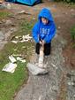
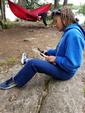
We where all up and ready to go eat a hearty breakfast at 5 a.m. at Britton's Café. The portions where huge and we all left over fed and ready to go back to bed, lol! We headed back to the bunk house and started little tasks such as double checking the fitting of everyone's packs, supplies, and gear. Our ride arrived around 930 and we loaded up and headed out. We arrived at the entry point at Mudrow Lake. The trip started right then, with a short portage to the lake from the parking lot. Everyone was still excited, no arguing from the kids yet. My goal was to be able to portage one of the canoes on this trip....Well first portage, done! Who whooooo, I did it with my bag on my back. I was feeling pretty strong and confident! The girls had expressed there opinion about who should be in which canoe....they made it clear they wanted the challenge of manning there own canoe and gear, so we let them. The three kids and all of their gear loaded into the 3 person Kevlar canoe. My fiancé and I and the rest of the gear where loaded into our canoe. Now Mudrow starts with a winding narrow trail that is shallow enough to see the sandy bottom. We let the kids go ahead of us, explaining that the three of them will have to get into a rhythm with each other to paddle with out hitting each others paddles together. They did ok, once we where in the open portion of the lake we passed the kids and paddled ahead....Wait...what's that noise...the kids where arguing! We turn around to find a paddle floating in the lake and the kids paddling in circles trying to get close enough to pluck it out of the water. We where laughing at the kids but they did not find this funny! They finally retrieved the paddle and quickly found there rhythm ( my guess is they didn't want to waste anymore time going in circles). We reached our next portage to Sandpit Lake, a short 60 rod walk. The girls had their pattern of doing things, unload, stretch, load up and start hauling gear, there brother was quick to learn this and between the three of them they managed to carry all the additional gear as well as theirs. I began the portage with the canoe and decided this time to leave my bag behind and portage twice...Wow, this seemed harder then the first portage. Shaking the thought of weakness out of my head i trudged on, silently cheering myself on with " you got this" , "almost done" and " no pain no gain!" My other half is behind me having to slow his pace so as not to run me over, lol. Alright another portage down! The kids where busy dousing themselves in bug repellent. Now on Sandpit lake the kids started looking better and better in there canoe. They tried to out paddle us and realized they would tire themselves out if they tried to keep in the lead. Third portage now to TinCan Mike Lake. My shoulders where aching I almost did not finish this portage, lol! I started my silent cheering to keep myself going, when out of now where I hear out loud "mom, you are so strong", "you got this mom", "I believe in you mom". . . Now i had no choice but to keep on because my son was cheering me on...whether he was afraid I was gonna drop the canoe and block the path or if he saw I needed some encouragement...im not sure but I knew I had to show him that even though somethings may be really hard to do, if we dig deep we can achieve it. Yes I took this moment to teach a lesson about not giving up. Finally the end of the portage appeared!! The girls ran back down the path to meet me and we hauled the canoe the rest of the way together. My other half was quietly telling me to only do what I can because, injury meant ending the trip and he didn't mind portaging both canoes. So I reluctantly agreed that he was right and he portaged both canoes the rest of the trip. We made it to Horse Lake finally! It was our destination for the first night. Now what I haven't mentioned yet is that there where 4 other canoes behind us...I told my fiance that I was nervous about not finding a spot on Horse especially with the canoes behind us. So to make a game we told the kids we where racing to find an open campsite. From the looks of it, there was only one open site...we paddled as hard as we could, but the closest canoe behind us had only 2 men and there packs in it...... Yep, they passed us and made it to the last open site before us. We admitted defeat and rested in the water at the mouth of Horse River. We talked among ourselves about plan B while we ate some snacks and drank some water. Our options where Four town Lake or paddle up the river to Wheelbarrow falls (which was our day trip destination). It was probably a couple hours past noon by now, our last big meal was at 5 a.m. that morning, but everyone agreed to the challenge of heading up the river. After all according to the map, there was an abundance of sites available on the lakes that awaited. The kids started showing signs of being worn out, but there attitudes remained high. They navigated the river ahead of us and scouted out the pull over spots and the portage spots. I believe there where 3 pull overs and 3 portages. We finally reached the end of the river and the kids were excited to find a campsite. We paddled to the right of Basswood Lake, no sights....we paddled to the left of Basswood Lake, no sights..... By now the kids where spent, they where tired, hungry and feeling as though we may never find a site. We portaged again to get on the other side of the falls to check those campsites. We let the kids hang back a bit and rest, paddling half way to crooked, we found no open sites. Back to the kids we went, we found 2 of the three weeping silent tears. One had lost her new hat and the other was over taken by exhaustion and hunger. My son, was comforting them both. We told them they had to portage one more time to get back to the lower side of Basswood lake. At this point, we all lost it and we sat and shared several minutes of hysterical laughter and tears and dubbed this trip the "paddle of tears"! We decided we had no other choice but to set up camp at the start of the portage on Lower Basswood Lake. It was now dark out, so we set up camp in the dark, everyone busy with there appointed tasks. One of the girls set up their the tent, my son readied the food, the other set up the perimeter of camp with thermacells and we set up, for the first time ever, our two person hammock tent. We had a supper of mashed potatoes with goulash and rehydrated mixed veggies. The food tasted awesome which we can't decide if it really was that good or if we where all just starving! We turned in for the night after we secured our tarps due to rain being expected throughout the night. 


Day 2 of 4
Wednesday, August 07, 2019 The next morning we woke up to hear other campers beginning there day. Hushed talk and excitement in each group that passed by our hammock tent. Remember we had to camp on the base of the portage. It was still drizzly out and my watch read 5:15. We started to get up, waking the kids, and pulling out breakfast bars, dried fruit and starting the coffee. One by one the kids emerged from their tent, sleep still in there eyes. We all sat in silence as we ate breakfast and enjoyed some hot coffee. The talk of our plans for the day started. We all agreed that we wanted to at least see the falls and agreed a small hike and sight seeing was a must prior to starting back down the river. Our goal was to hope for an open site on Horse today and plan B was to portage to Four Town Lake if none where available. By the time we had our camp packed up, we had counted 6 canoes that all planned on heading to Horse. We realized very quickly that an open spot on Horse Lake was probably not going to happen, and we where right. We reached horse and nothing was open. We began heading to the portage that led to Fourtown Lake. It was now a little past noon. We came to the first campsite on the map, it was taken. The occupants where a friendly older crew, that told us about there difficulty finding a camp site the past couple nights as well. We kept on, the 2nd campsite taken and the third. The kids where getting anxious and starting to worry that we again would be stuck paddling all day with no real campsite to call home for the next 2 nights. Finally the 5th site we came to was open. We took it! it was a beautifully laid out site, spacious and great views. The downfall was the openness left us exposed to the wind. We set up camp and the kids began to explore. We got a fire going, which proved difficult when the wind was working against you. So we walked around scouting any larger rocks to carry back to camp and help build up around the fire pit to protect the grate and the flames from the wind. This also kept us off the lake as the wind was making some pretty good sized whitecaps and we dare not take the kids out on that. We tried some shore fishing, with no luck. This day came to an end with a good supper of spanish rice, dehydrated hamburger and corn muffins. We finished it out with some good old story telling and everyone settled in for the night around 9 p.m. 


Day 2 of 4
Thursday, August 08, 2019 I have the inability to sleep in, so I was up bright an early at 5 a.m. again. First order of business was to get the fire going so I can have some nice hot coffee. The wind was still topping out at 25-30 mph, per the weather radio. My allergies have started to kick up with all the wind blowing things about and I was over hearing the constant wind at this point. Got the fire started, coffee brewing, breakfast mixed and ready to be cooked (chocolate oat pancakes and scrambled eggs). The kids started stirring and emerging from the tent one by one. My fiancé is now up and started gather more wood for later that day. This, I feared, would be a long day with the wind constantly blowing that meant we would be stuck on land with no adventures on the water. The day was slow to pass, we played games with the kids that involved exploring the area along the shore, finding different animal tracks, flowers, plants, etc. We read books, tried fishing off the shore some more (with no luck) and the kids made A LOT of spears, lol! They took turns using the axe to help gather wood, they each carved ornamental designs in the spears they made to burn. We had a big lunch and supper and everyone was in bed early that. 


Day 5 of 4
Friday, August 09, 2019 Last day here, departure day! I had convinced my 12 year old daughter to get up early with me and get on the lake early while the wind was down. We fished for 2 hours with only the luck of the hook snagging the top of small mouth on our way back to camp, lol! She was thrilled though because last year she was the only one who did NOT catch a fish and this year she was the only who DID catch one. When we got back to camp everyone else was up and busy with tasks of tearing down camp. Coffee was made as was breakfast (strawberry fry bread, biscuits and gravy and scrambled eggs. We had snacks left for the trip out (snickers, trial mix and beef jerky). Tarps where taken down, tents stowed away, bags filled, visual checks to ensure we left nothing behind where done. We started hauling the gear and bags down to where we had the canoes stowed. Whats that under the paddle....a snake! This was about the most excitement this whole trip!! Then another just a couple feet away. The kids watched them slither out of the cracks between the rocks and asked if they could feed the remaining leeches to the snakes. We let them and it was national geographic up close and personal for them, lol! The snakes gobbled the leeches down one by one then lay there to bask in the sun. We loaded our canoes and advised the kids to stay close to us as the wind was still a concern. We paddled against the wind for the duration of Fourtown lake, once we hit the first portage the lakes where situated between hills and there was nearly no wind. We where all glad to be out of the wind. All along the way we did not see a single open campsite. We had a few more portages one in which we hid and scared the kids (we could not resist). We enjoyed the trip this year but we all agreed it was not one we would want to repeat! 


discuss this trip report (5 comments) - last post on December 06, 2021