BWCA Entry Point, Route, and Trip Report Blog
July 09 2025
Entry Point 14 - Little Indian Sioux River North
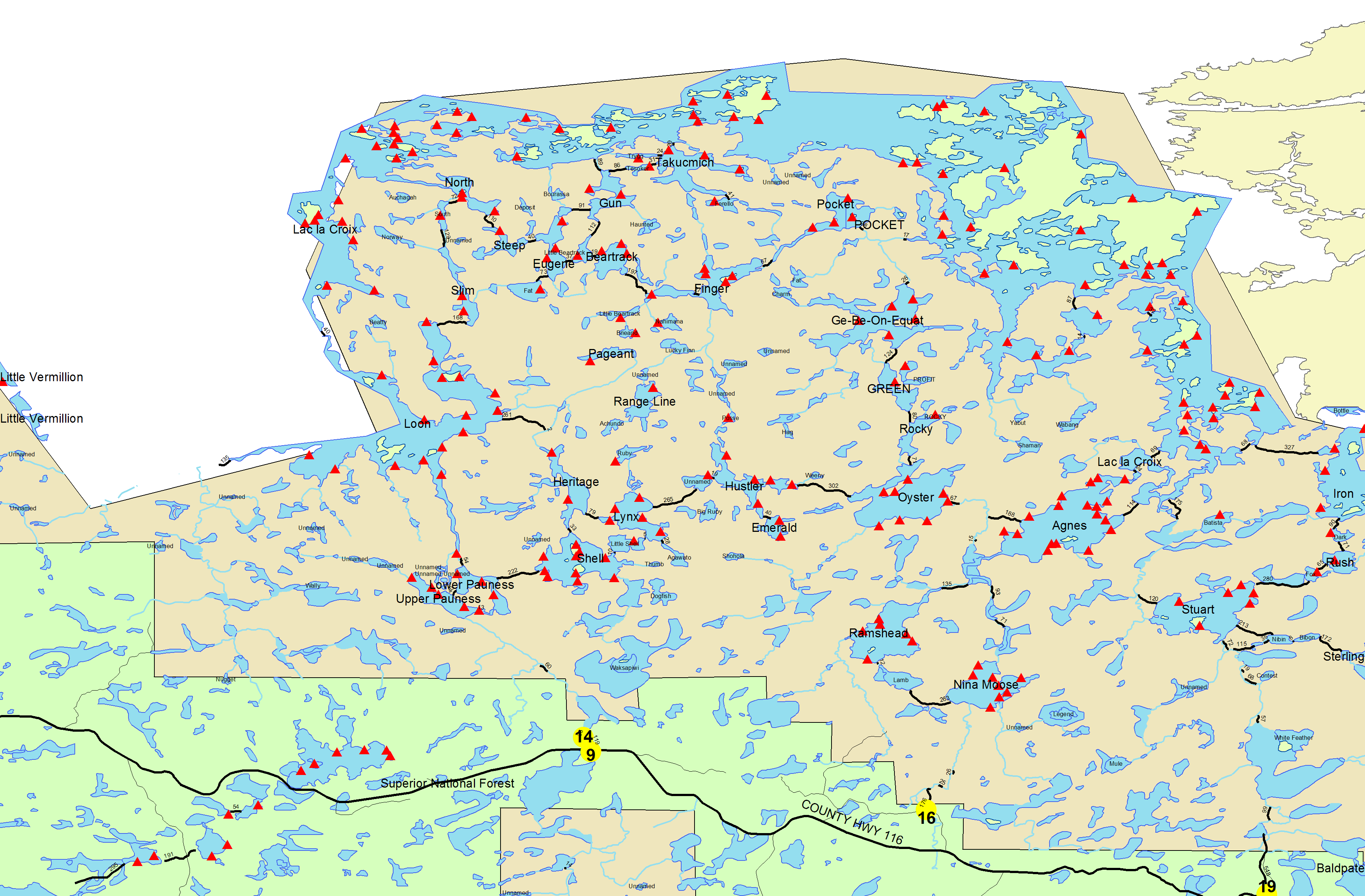
Little Indian Sioux River (north) entry point allows overnight paddle only. This entry point is supported by La Croix Ranger Station near the city of Ely, MN. The distance from ranger station to entry point is 32 miles. Access is a 40-rod portage heading North from the Echo Trail.
Number of Permits per Day: 6
Elevation: 1364 feet
Latitude: 48.1466
Longitude: -92.2103
Number of Permits per Day: 6
Elevation: 1364 feet
Latitude: 48.1466
Longitude: -92.2103
Crooked Lake
by placid
Trip Report
Entry Date:
June 09, 2008
Entry Point:
Mudro Lake
Number of Days:
7
Group Size:
4
Trip Introduction:
2nd Annual Father / Son Trip
Day 4 of 7
Monday, June 09, 2008 Arrive in Ely at 7:30. Pick up permit and Souris River Canoes from CCO. Run down to The Boathouse for dinner and several pints. Still don't understand how they are a brewpub without house beer. You have to enjoy your beer prior to going in for a week!! Stay in the bunkhouse at CCO.
Day 8 of 7
Tuesday, June 10, 2008 Wake up at 4:15am, hit the showers. Grab coffee and breakfast at the gas station across the street. Get the troops together and head off to the Mudro EP. New signage at the EP turnoff? Forgot how long it takes to get to Mudro...probably just my eagerness to get in the canoe. Crisp air, overcast, perfect paddling/portaging weather. Hit the water at 6:15am, 6:30 first loon call, reminds you why you come to the BWCA. Continue to the first of 3 portages to Fourtown, the 143 rod is the least favorite of the entire trip. Into Fourtown, slight rain, notice one campsite with 5 canoes, thought it was max 4? ANYWAY. On to Boot. Short damp paddle to Fairy. No campsites occupied. Fairy is also empty. As well as Gun. Stop for an early lunch at "Resort Camp" on Gun. Shoot down the barrel and off to the mile hump... Last time we did this was with a 70+ lbs Grumman, this time 44 +/- lbs Kevlar. Thank you Dupont. 1 hour for the double portage. Next to Wagosh and then Niki. Up the creek to Chippewa. Should camp at Chippewa, great spot and never know there were people traveling by.To Papoose and finally the bottom of Friday. We travel north and find more canoes then we had seen the rest of the trip. Campsites are very full, save one. We take it, would not be our first choice though. Grill up some steaks as reward, set up camp and retire before the rain sets in. 
Day 3 of 7
Wednesday, June 11, 2008 Sleep in late, we are on vacation. Get around and start fishing. Weather looks indecesive. Sun, rain, clouds, repeat. (This continues throughout the trip, so I'll spare reminding you that this happened a lot each day) We find the walleye and start the intensive pursuit for dinner. Catch one immediately. then they shut off like a switch, leechs, worms, artificials, nothing. I'll blame the weather, of course I am not Al Linder either. Catch some decent northern, nothing spectacular. Overall a good day. 
Day 11 of 7
Thursday, June 12, 2008 Get up early and enjoy 2 pots of coffee prior to going out. My dad lands a nice 4lbs walleye 10 mins into fishing. Of course no other fish would bite. Frustrating. Brother in law catches a 5lbs eye later on. Catch more northern and some smallies. Cook dinner and decide to head out around the island we are camped on. slow fishing but the clouds were amazing. Until they turn from white to black. We head for camp at a quick pace, secure the site, and jump under the rain fly. The water boils with the big drops, which give way to pea sized hail. quite a site to see from under the rainfly. 

Day 15 of 7
Friday, June 15, 2008 Finally, the circling weather is burning off. Sun and the occaisonal (welcome)cloud. Today we catch more fish then the other days combined. My brother-in-law really cleans up on the smallies. one 20 incher. Our canoe catches a lot of 4-8 lbs northern and a couple of nice smallies. Great day for fishing. Watched the sunset. 
Day 20 of 7
Saturday June 16th, 2008 We pack up camp by 6:45am and head east into Thursday Bay. Great day for traveling, cool and sunny. Lots of water moving. Greated by an eagle as we make the turn in Crooked that leads to Wednesday Bay. Getting a little worried about the volume of fast moving water and what the Horse River will look like. We press on. Meet some friendly campers on their 2nd day in, heading for Friday. Stop in Wednesday for a break and a snack. We start to meet canoes going north quite regularly now. We make it past the pictographs, much lower then last year. We hear lower Basswood falls, nothing like last year. Sneak up to the portage and enjoy the view. Perplexed as how the egg shaped rock is where it is. Mosquitos find us for the first real time. Paddle down the Horse Highway... I mean River. 6 canoes met before the first portage. We continue to meet groups but not on the portages, save 1. Paddle through 2 of the 3 rapids at the end of the Horse River with 1 pull around. Helped out one group with our spare paddle for short while, as the front canoer snapped their wood bent shaft like a twig in the rapids! Amazing the rear canoer managed up the rapid to safety. They duct taped the 2 pieces together and said they were good to go. Hope they made it out ok. Camped on Tin Can Mike Lake to make an early escape in the morning to the truck. 
Day 23 of 7
Sunday June 17, 2008 We break camp by 6:45 and hit the truck before 8:45. I think they need to make the portage from Sandpit to Mudro an 80% grade instead 60% :) Great hill, but bittersweet as we hit Mudro with a headwind. Great Trip, never long enough, is it EVER?!
discuss this trip report (2 comments) - last post on December 28, 2023